Showing posts with label NORSU. Show all posts

Monday, August 21, 2017

Pseudokarst in Guintabon volcanic bombs

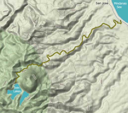
Photo 1. Road going to Lake Balinsasayao.
San Jose is a municipality of Negros Oriental.
Taken from: http://www.thelonerider.com/2010/
dec/balinsasayao_bike/images/terrain_map.jpg
The term pseudokarst refers to karst-like features that formed wherein solution is not the dominant process, in contrast to true karsts. Among many examples that would not be discussed here, pseudokarst in volcanic landscapes have been described, such as lava tunnels, lava tubes, lava stalactites, lava stalagmites, and rough surfaces above a lava field, where the ceilings of lava tubes have collapsed. 

Here, I would like to make a case of probable pseudokarst features in volcanic bombs found along the footslopes of Guintabon in Negros Oriental, Philippines.

A fine example of a volcanic bomb showing pseudokarst features is shown in the photograph above. Its composition is that of basalt, with numerous andesite xenoliths. This example measures roughly 2 m x 4 m. While it is not the only example found in the area, this example shows the most well-developed pseudokarst features.

Photo 2. Volcanic bomb showing probable pseudokarst features, found along the road halfway to Lake Balinsasayao. Note the flute-like features, much like solution runnels (rinnenkarren) found in karst environments. Scale: Human around 5 feet high.
What is easily seen in this volcanic bomb are fist-wide vertical flutes rimming the circumference of the bomb, much like the solution runnels (rinnenkarren) found intrue karsts. The interior of the runnels are smooth walled, and show no difference in appearance compared to other parts of the  bomb. This likely points that these runnels formed at the same time the volcanic bomb is cooling, that is, when it was still up in the air.


Photo 3. A close up of the volcanic bomb shown in Photo 1. One of the runnels (left side of the picture) appears to be smoothed by overland flow, but overland flow alone is not likely to produce these features, as explained below. A hornblende-phyric andesite xenolith is found in a cavity 10 inches below the compass, and a larger one 10 inches SE of the compass. Vesicles can also be observed. The other white spots are lichen growths. Scale: A compass, roughly 5 inches in diameter. 
The volcanic bomb is shaped akin to that of a gas stove flame, with curved bases and flared tops. I think this shape is most likely a response to the aerodynamic drag such a large bomb creates as it falls from the sky.

But what is clear is that these features are not a result of solution, such as by rain. For a place like Philippines in which rain is ubiquitous, such features, if a result of solution by rain, should be the norm rather than the exception.


Tuesday, January 26, 2016

Use of soil maps in geology

Being a student geologist from the Philippines, one of my biggest frustrations when going out in the field is the veneer of soil and 'lush' vegetation which hides the underlying lithology of the area.

This situation is unavoidable as my place, Negros Oriental, is in a tropical climactic zone - sunny, humid, and plenty when it comes to rainfall - which promotes intense chemical and biogenic weathering. This in turn accelerates the processes of soil formation.

But actually (as I have realized from one of my great epiphany moments), you could use soil maps, and a little knowledge of pedology (the study of soils), to aid you in uncovering the lithology of an area!

Here is how I intend to use this new-found knowledge in one of my assigned work in our Principles of Stratigraphy class.

As you could see below, the area I am concerned about (labelled Field Points) has a soil cover made up of the Faraon clay variety.

Picture 1. The Soil Map of South-eastern Negros
Consulting an authorized literature, such as the Simplified Keys to Soil Series - Negros Oriental (Philippine Rice research Institute, 2014), the Faraon clay series is "a calcareous, fine-textured soil with less than 65% clay, developed from the weathering of the soft and porous coralline limestones..."

Thus, without going to the field, I now have an idea about the lithology of the area I am studying, that is, it is composed of coralline limestones. This means that this area has been underwater, as coralline limestone are only deposited in shallow marine environment.

But of course, verification must be achieved if possible. Below, you could see a picture of a building stone and sand quarry in the area, which shows the subsurface strata.


Picture 2. This shows the quarry excavation found in the area. Note the thick limestone cap on top, with the thin Faraon clay soil series on top of it, as seen clearly below the bamboo. Below the limestone cap lies a thick, matrix-supported(?) calcareous conglomerate of cobble to boulder -sized clasts. Further below are interbedded alluvial sands(?) and pyroclastics. Image courtesy of Gladys Magsanay (2016).
Because of this verification, we can now infer from the soil map that those areas covered by the Faraon clay  is underlain by either a limestone cap, or a calcareous conglomerate bed.

Of course, this method of inference can only be used for residual (or authigenic) soils, which are formed from the weathering of the rock at source itself. In contrast with the allogenic soils, which are transported from another place, the soil type would tell the lithology of the source of the soil itself.

There are many other ways to incorporate soil maps in geologic analysis. Arguably, they are important tools that student geologists should be familiar about them.